

LA weather forecast: Pair of winter storms bringing more rain, mountain snow
Weather Forecast for Monday, March 10
The latest forecast and air quality conditions for the greater Los Angeles area, including beaches, valleys and desert regions.
LOS ANGELES - Enjoy the (short-lived) sunny weather while it lasts!
More late-winter storms are on the way to Southern California this week, with Wednesday and Thursday shaping up to be the heaviest days of rainfall before another system moves into the area next weekend, according to the National Weather Service.
Key points:
- Storm 1 (Monday night - Tuesday): Rain showers, light mountain snow, areas of gusty southeast winds; low threat for debris flow/flooding
- Storm 2 (Wednesday - Thursday): Very cold system with potential for significant mountain snow with snow levels; moderate to heavy rain and higher rates, along with strong gusty south/southwest winds especially for the mountains
Timeline:
Light rain is possible early or late Tuesday, according to the National Weather Service.
A cold front will move over the area overnight Wednesday into the predawn hours of Thursday, presaging a storm that will carry the potential for flooding.
A Flood Watch has been issued for 4 p.m. Wednesday to noon Friday.
Forecasters are predicting a three-hour to six-hour period of moderate to heavy rain, with a half-inch to 1 inch per hour. This system will also likely be the biggest "snow maker" of the season, with 1 to 2 feet of snow forecast for higher elevations.
"Models have remained consistent, showing the strongest part of the storm coming through Wednesday night into early Thursday," the NWS said. "Still looking roughly 75% of the total rain from this system falling during that peak period."
Recent burn areas could experience some shallow debris flows, and chances of this will increase if thunderstorms develop, officials said, likely late Wednesday into Thursday.
Mountain snow:
A Winter Storm Watch is in effect from Wednesday afternoon through Friday morning for a portion of southwest California, according to the NWS.
This is due to heavy snow possible, with 12 to 24 inches possible above 6500-7000 feet, 6-12 inches 5500-7000, 1-5 inches 4000-5500 feet, and up to an inch as low as 3000 feet.
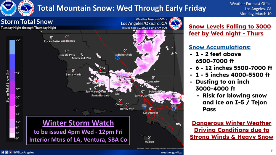
"The snow levels will drop to around 3,000 ft and a few inches of snow is possible over the Grapevine and other lower elevations passes," the NWS said.
Officials warn travel could be very difficult to impossible due to the hazardous conditions possible Wednesday evening and Thursday morning.
What's next:
Current forecasts also show rain over most of the Southland next Saturday and Sunday.
The Source: Information for this story is from the National Weather Service.