

Los Angeles weather updates for Thursday, Mar. 13
Crews conduct water rescue in Orange County
Multiple people were saved during a swift water rescue in San Juan Capistrano late Thursday morning.
An atmospheric river began hammering down in Southern California, bringing heavy rain and triggering mandatory evacuation orders in some areas.
With the downpours, residents in some communities prepared for flooding and possible mudslides, particularly those in recent burn scar zones.
In addition to the widespread rain, parts of Southern California will be hit with gusty winds and possible thunderstorms with small hail.
Heavy rain slams Southern California
The peak of a winter storm brought heavy rain and mountain snow to Southern California.
Follow FOX 11's live blog with the latest updates provided on the Southern California weather below:
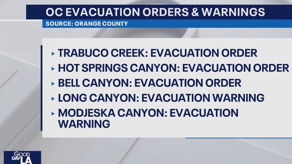
Evacuations Orders and Warnings
Storm prompts evacuations in Orange County
Some communities in the Santa Ana Mountains were under evacuation orders amid a powerful storm in Southern California.
Evacuation orders/warnings:
The Los Angeles Fire Department has issued the following evacuation warnings for recent burn areas effective from 7 a.m. March 12 to 6 p.m. March 13:
- PALISADES FIRE AREA (Malibu and Pacific Palisades): Getty Villa area, Highlands near the burn areas, Bienveneda area near Temescal Canyon Park, Rivas Canyon/Will Rogers State Park area, Mandeville Canyon above Tanners Road, Old Ranch Road and Rustic Creek.
- SUNSET FIRE AREA (Hollywood Hills): East and South of Runyon Canyon.
- HURST FIRE AREA (Sylmar): Olive Lane in the Oakridge Mobile Home Park.
EATON FIRE AREA:
- Evacuation Order Zones (Effective 7:00 AM March 12 – 6:00 PM March 13, 2025)SMD-E001, SMD-E002A, SMD-E002B, SMD-E002C, SMD-E003, SMD-E004, SMD-E005, SMD-E006A, SMD-E006B, SMD-E007, SMD-E008, SMD-E009, SMD-E010A, SMD-E010B, SMD-E011A, SMD-E011C, SMD-E012A, SMD-E012B, SMD-E012C, SMD-E012D, SMD-E013B, SMD-E014B
- Evacuation Warning Zones (Effective 7:00 AM March 12 – 6:00 PM March 13, 2025)SMD-E011D, SMD-E013A, SMD-E014A, SMD-E015, SMD-E016
>> TAP OR CLICK HERE TO SEE AN INTERACTIVE MAP OF THE EVACUATION AREAS <<
Officials said houses in warning areas considered to be high risk will get a visit from LAPD today to issue specific evacuation orders. A flyer will be left at the door if you aren't home.
Road Closures:
- The southbound side of Pacific Coast Highway, from Seapoint Street to Warner Avenue, in Huntington Beach, has been closed due to heavy rain, Caltrans reported late Thursday morning.
Evacuations lifted
6 p.m.: Evacuations have been lifted for all of Sierra Madre and areas previously impacted by the Airport Fire.
Stay aware
3:35 p.m.: "Some storms over southwest California are strengthening and could become severe through 5pm today with strong winds, heavy rain, hail, and even a tornado. Bottom line, STAY AWARE. If the weather looks ominous, or you hear thunder, be safe and GO INDOORS," the NWS said.
Wind Advisory
1:40 p.m.: A Wind Advisory remains in effect until 8 p.m. Thursday for the following: Orange County coastal and inland areas, San Bernardino and Riverside County valleys - the Inland Empire, San Diego County coastal areas and valleys, and Santa Ana. mountains and foothills.
According to the NWS, gusty winds 15 to 25 mph with gusts of 30 to 40 mph are expected, leading to possible down trees and power lines. Power outages may be a result.
Confirmed tornadic activity
9 a.m.: The National Weather Service confirmed a tornado passed through the Pico Rivera area at around 3:15 a.m. Thursday. It had a 1-mile path length, was 80 yards wide and lasted for about two minutes with wind speeds up to 85 mph, officials said during a press conference held after the initial assessment of the area.
The NWS said there is the potential for more small, brief tornadoes with this storm system.
NWS investigates reported tornado in Pico Rivera
Good Day LA's Gigi Graciette was on the ground as a team with the National Weather Service investigated a reported tornado.
Weather Alerts
7:05 a.m.: Several weather alerts are in effect across the region, including wind alerts through 10 p.m.
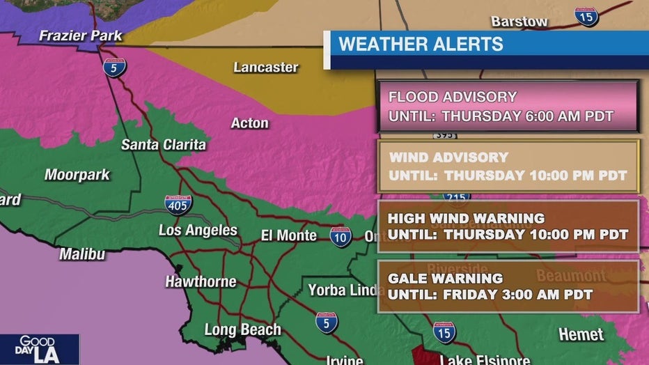
See more details about additional alerts below.
Winter Storm Warning
A Winter Storm Warning is in effect until 11 p.m. Thursday in the San Bernardino and Riverside County mountains. This includes Big Bear, Running Springs, Wrightwood, and Crestline.
Along with heavy snowfall, winds could gust up to 60 mph.
Additional snow accumulation:
- 4 to 8 inches at elevations from 5000 to 6000 feet
- 8 to 14 inches at elevations from 6000 to 7000 feet
- 18 to 25 inches at elevations above 8000 feet
Flood Watch
A Flood Watch is in effect through 6 p.m. Thursday for several portions of Southern California, including:
- Catalina and Santa Barbara islands
- Santa Clarita Valley
- Ventura County beaches
- Ojai Valley
- Malibu Coast
- Palos Verdes Hills
- Downtown LA
- San Fernando Valley
- Santa Susana Mountains
- San Gabriel Valley
- San Bernando and Riverside County valleys
- The Inland Empire
- Orange County coastal areas
- Santa Ana Mountains and foothills
- San Bernardino County Mountains
- Orange County inland areas
Tornado may have touched down in Pico Rivera
6:15 a.m.: The National Weather Service confirmed they were investigating reports of a tornado that touched down in Pico Rivera. SkyFOX flew over the area and showed downed trees.
Downed trees in Pico Rivera prompts tornado probe
The National Weather Service confirmed they were investigating reports of a possible tornado in Pico Rivera.
California mountain communities receive more snow
5:30 a.m.: Early morning video showed snow falling in Frazier Park and Mammoth Mountain. Those wanting to travel to see the fresh blanket of snow are encouraged to take their time and to drive carefully.
California mountain communities get more snow
The latest winter storm brought heavy rain and mountain snow to California.
Be prepared to take action
Impacts and Precautions: Residents in areas prone to flooding should monitor forecasts and be prepared to take action if flooding develops. Those traveling in affected areas should exercise caution, as hazardous conditions could make travel difficult or impossible. It is advised to keep an extra flashlight, food, and water in vehicles in case of emergencies.
What’s Next: Residents should stay informed by checking the latest weather updates and road conditions. The National Weather Service advises calling 511 for state-specific road conditions.
The Source: Information provided by the National Weather Service, the FOX 11 Weather Team and local authorities.