

Los Angeles weather: More rain, flood concerns on the way before clear weekend
Rain in Los Angeles brings mudslide concerns
Rain in Los Angeles is expected to continue for at least another day. In burn scar areas in the Pacific Palisades, Pasadena and Altadena, residents are preparing for mudslides and flooding.
LOS ANGELES - After consistent rain across Southern California all day Wednesday, the rough weather is expected to continue with heavy pockets of rain across the region Thursday.
While this storm is expected to move out of the region ahead of the weekend, more storms are forecast for next week.
THE LATEST SOUTHERN CALIFORNIA FORECAST
Rain in Southern California
What we know:
Rain moved into the area during the morning rush hour on Wednesday, and didn't let up for much of the day. Areas like the Eaton Fire burn scar area saw nearly an inch of rain throughout the day, according to LA County Public Works.
Sierra Madre has issued an evacuation warning until Friday.
SUGGESTED: LA County, Pasadena sue SoCal Edison over Eaton Fire damages
Malibu and areas in the Palisades Fire burn scar area saw less total rain on Wednesday, but the rain did cause mud to slide onto Pacific Coast Highway throughout the day, with crews working hard to clean up the spills.
Rain brings mud onto PCH in Malibu
More rain in Los Angeles caused some mud to spill onto PCH on Wednesday.
By Wednesday night, though, much of the first batch of rain had moved out of the area. But it will return on Thursday.
When will it rain?
Timeline:
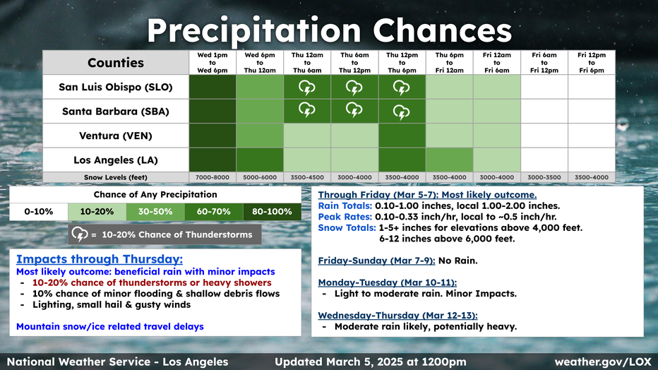
Rain on Thursday could start early, with pockets approaching LA County around 5 a.m. - 6 a.m., according to FOX 11's Chief Meteorologist Adam Krueger. The rain isn't expected to be nearly as consistent on Thursday as it was on Wednesday, but is expected to come in heavier pockets throughout the day.
"There will be times [Thursday] where it might be kind of quiet, maybe midday," Krueger said.
More rain is expected to hit in the afternoon, before eventually moving out to the east by Thursday night. Overall, rain totals on Thursday are expected to be less than on Wednesday.
The National Weather Service also predicts a 10-20% chance of thunderstorms in the region through Thursday.
Lower temperatures, wind advisories
Thursday is expected to feel much cooler.
Highs across the area are only expected to be in the 50s on Thursday, Krueger said. In certain areas, the cooler temperatures will combine with heavy winds.
The National Weather Service has issued a wind advisory in the deserts until 1 a.m. on Friday, and another advisory along the coasts in Los Angeles and Ventura counties until 1 p.m. on Thursday.
Snow forecast
Weather forecast for Wednesday, March 5
The latest forecast and air quality conditions for the greater Los Angeles area, including beaches, valleys and desert regions.
The colder air moving into the area with this storm lowers the snow level, Krueger said. Snow will be expected in areas above 3,500 feet, with heavier snow above 6,000 feet.
Wrightwood could see between six and eight inches of snow, while Big Bear and Idyllwild could see up to a foot or more, according to Krueger.
More rain next week
What's next:
This storm is expected to clear out by Thursday night into Friday, but more rain is in the forecast for next week, with storms predicted for Monday into Tuesday. Another storm could make its way to the area between Wednesday and Thursday, Krueger said.
The Source: Information in this story is from the National Weather Service and FOX 11 Chief Meteorologist Adam Krueger.