

Heavy rain, mudslides leave destruction across Southern California
Weather forecast for Friday, Feb. 14
The latest forecast for the greater Los Angeles area, including beaches, valleys and desert regions.
The bulk of a significant storm that drenched Southern California is behind us as stormy conditions began clearing out.
Similar to the aftermath of the catastrophic Eaton and Palisades fires, Angelenos are once again picking up the pieces after burn scar areas got hit by flooding and mudslides.
Mandatory Evacuation Orders (Leave Immediately)
Mud and debris swamp parts of Palisades Fire zone
Parts of Malibu and the Pacific Palisades remain under evacuation orders and warnings as a storm drenched Southern California.
The following areas are under mandatory evacuation orders due to the risk of flooding and debris flows:
Eaton Fire Burn Area: Altadena, Sierra Madre
SMD-E019, SMD-E001, SMD-E002C, SMD-E002B, SMD-E003, SMD-E004, SMD-E014-B, SMD-E013-B, SMD-E006-B, SMD-E007, SMD-E008, SMD-E009, SMD-E012-C, SMD-E010-A, SMD-E012-B, SMD-E012-A, SMD-E011-C, SMD-E011-A, SMD-E011-B
Palisades Fire Burn Area: Pacific Palisades, Malibu
- 106 homes under evacuation
Affected neighborhoods:
- Getty Villa area
- The Highlands (near the burn zone)
- Bienveneda area (near Temescal Canyon Park)
- Reseda Blvd/Marinette Road (near Will Rogers State Park)
- Mandeville Canyon (above Tanners Road)
Sunset Fire Burn Area: Hollywood
- 9 homes under evacuation
Affected neighborhood:
- East and south of Runyon Canyon
Hurst Fire Burn Area: Sylmar
- 4 homes under evacuation
Affected neighborhood:
- Olive Lane (in the Oakridge Mobile Home Park)
Franklin Fire Burn Area: Malibu
- 26 properties under evacuation
Affected area:
- Franklin Fire Burn Area
Evacuation Warnings (Be Ready to Leave at Any Time)
Residents in these areas should prepare for possible evacuation and stay updated on official alerts:
Palisades Fire Area: Pacific Palisades
- Some neighborhoods are listed above, and include the Getty Villa, Highlands, Bienveneda, Reseda Blvd, and Mandeville Canyon.
Sunset Fire Area: Hollywood
- East and south of Runyon Canyon.
Hurst Fire Area: Sylmar
- Olive Lane in the Oakridge Mobile Home Park.
Duration: These evacuation orders and warnings are in effect from 7 a.m. Thursday, February 13, 2025, until 2 p.m. Friday, February 14, 2025.
If you are in a mandatory evacuation zone, you should leave immediately. If you are in a warning zone, be prepared to leave if conditions worsen.
Follow FOX 11's live blog with the latest updates provided on the Southern California weather below:
Cleanup continues
10:15 p.m.: Residents in Altadena are picking up the pieces and cleaning up again… this time mud as several mudslides and flooding occurred in the burn scar areas.
Mudslides hit Eaton fire burn area following powerful storm
Widespread cleanup continues in Altadena after a powerful storm brought flooding and mudslides to the area, bringing more chaos to those impacted by the Eaton Fire.
Move in day ruined by the mud
10 p.m.: It wasn't the homecoming Scott Von hoped for. He had been displaced by the powerful fire that devastated Malibu. Friday was supposed to be move in day, but Thursday an atmospheric river dumped mounds of rocks and mud at the front door of his home on Pacific Coast Highway.
Home saved from fire, but mudslide delays moving back
It wasn't the homecoming Scott Von hoped for. He had been displaced by the powerful fire that devastated Malibu. Friday was supposed to be move in day, but Thursday an atmospheric river dumped mounds of rocks and mud at the front door of his home on Pacific Coast Highway.
Mammoth Mountain Avalanche
4:13 p.m.: Two Mammoth Mountain Ski Patrol staff were rescued from an avalanche on Lincoln Mountain. One was extracted from the scene and is responsive, the other patroller was transported to Mammoth Hospital with serious injuries.
The area was closed to the public at the time of the incident. The entire mountain and lift operations closed at 12 p.m. for the day. The mountain received approximately 6 feet of snow within the last 36 hours.
Avalanche at Mammoth Mountain injures 2
An avalanche at Mammoth Mountain injured two ski patrol officials. One of them was taken to the hospital with serious injuries.
Tornado in Oxnard
3 p.m.: A tornado touched down in Oxnard Thursday. The tornado hit several trailer parks in southeast Oxnard, according to the NWS' Ariel Cohen.
Cohen called the tornado "weak," with wind speeds between 75 and 90 mph. The tornado traveled from the Country Club Mobile Estates to the Ocean-Aire Mobile Estates, traveling about a half mile, according to Cohen.
Tornado in Oxnard damages several homes
A tornado ripped through parts of Oxnard on Thursday as Southern California was hammered by a powerful storm. Several homes were damaged, but thankfully no one was reported injured.
Debris flow near Big Bear
Vehicles swept away in mudslide on Highway 330
Several vehicles were swept away in a massive mudslide on Highway 330 in San Bernardino following significant rain on Thursday evening.
12:30 p.m.: A major debris flow trapped multiple cars on Highway 330. The mudslide happened on Thursday night, about one and a half miles north of the City Creek Fire Station.
The debris flow closed the portion of the highway between Live Oak and Highland Avenue.
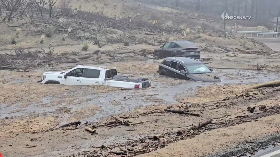
Some were still trapped on Friday morning. According to officials, three vehicles had been washed away and ended up in a nearby gulch.
It's unclear when the road would be reopened.
Sign Blows off building in downtown LA
12 p.m.: While the rains have passed, heavy winds have continued in the area. The wind was so strong in downtown Los Angeles on Friday that it ripped a massive tarp-like sign off the side of a building. Video from the Citizen app showed the display on the side of a building near the intersection of W. Olympic Boulevard and S. Burlington Avenue. The sign flaps in the wind for several minutes before it rips off the building.
Aiport Fire evacuations lifted
11:15 a.m.: On Friday morning, the Orange County Sheriff's Department lifted all mandatory and voluntary evacuations related to the Airport Fire, including Trabuco Canyon, Hot Springs Canyon, Bell Canyon, Long Canyon and Modjeska Canyon.
Section of PCH to remain closed until further notice
10:20 a.m.: After a storm drenched Southern California, mud and debris flow hit the Palisades Fire burn scar zone. Caltrans said they have issued a hard closure of PCH between Chautauqua Boulevard and Carbon Beach Terrace until further notice due to heavy flooding and mudslides.
Storm leaves behind muddy mess in Sierra Madre
10:00 a.m.: Overnight and morning footage showed mud and debris flow in Sierra Madre.
Sierra Madre hit with river of mud following rain
Heavy rainfall has triggered dangerous mudslides, swallowing streets near Grandview Ave & Anita Crest. Mandatory evacuations remain in place for areas near the Eaton Fire burn scar. Officials urge those still in their homes to shelter in place until roads are cleared.
Weather Alerts
6:20 a.m.: The following weather alerts are in effect in the Southland.
Wind Advisory
- A Wind Advisory is in effect for parts of the Antelope Valey including Lancaster, Palmdale, Lake Palmdale, Lake Los Angles through 4 p.m. Saturday.
High Wind Warning
- A High Wind Warning in effect for the San Bernardino County Mountains through 4 p.m. Saturday.
High Surf Advisory
- A High Surf Advisory is in effect until 3 a.m. Saturday for the Malibu Coast and LA County beaches.
- A High Surf Advisory is in effect through 4 a.m. Saturday for the Orange County coast.
- A High Surf Advisory is in effect for Ventura County beaches through 3 p.m. Saturday.
Rainstorm drenches SoCal
6:00 a.m.: Video from Thursday night shows the storm caused flooding, as well as mud and debris flow across the region.
Latest storm soaks SoCal
A significant storm that moved through Southern California drenched the drenching, causing flood as well as mud and debris flow.
Storm begins to move out
5:50 a.m.: FOX 11’s Soumada Khan said the peak of the storm is behind us as pockets of rain hit parts of Southern California on Friday morning.
Weather Forecast for Friday, Feb. 14
The latest forecast for the greater Los Angeles area, including beaches, valleys and desert regions.
Be prepared to take action
Impacts and Precautions: Residents in areas prone to flooding should monitor forecasts and be prepared to take action if flooding develops. Those traveling in affected areas should exercise caution, as hazardous conditions could make travel difficult or impossible. It is advised to keep an extra flashlight, food, and water in vehicles in case of emergencies.
What’s Next: Residents should stay informed by checking the latest weather updates and road conditions. The National Weather Service advises calling 511 for state-specific road conditions.