

Severe storm drenching Los Angeles this week
Weather forecast for Wednesday, Feb. 12
The latest forecast for the greater Los Angeles area, including beaches, valleys and desert regions.
An atmospheric river is moving into Southern California, and forecasters predict the region could see the heaviest rain of the season.
The anticipated heavy rain could also trigger flooding and mudslides.
Follow FOX 11's live blog with the latest updates provided on the Southern California weather below:
Heavy rain, expected flooding lead to evacuations in LA, OC
A flood watch is in effect for Los Angeles as a storm continues to soak Southern California. The incoming rain has forced officials to issue evacuation orders in LA County and voluntary evacuation warnings in Orange County.
Malibu schools closed
6:00 p.m.: All Malibu schools will be closed Thursday, Feb. 13 and possibly Friday, Feb. 14, due to road closures and weather concerns. The district said they will reach out to students and families regarding remote teaching and learning.
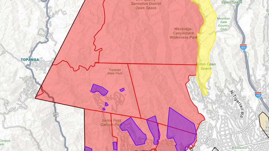
Evacuation warnings for burn scar areas
4:00 p.m.: The LAFD announced evacuation warnings that will take effect at 7 a.m. Thursday for areas near recent burn areas. The warnings will impact:
- in the Palisades Fire area: the Getty Villa area, Highlands near the burn areas, Bienveneda area near Temescal Canyon Park, Reseda Boulevard area/Marinette Road near Will Rogers State Park, and Mandeville Canyon above Tanners Road;
- in the Sunset Fire area: east and south of Runyon Canyon;
- in the Hurst Fire area: Olive Lane in the Oakridge Mobile Home Park.
Fire officials say specific homes considered to be at high risk will be subject to mandatory evacuation orders. Those residents will be contacted directly by the LAFD to be notified.
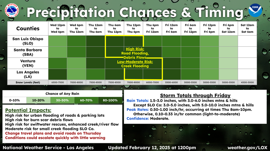
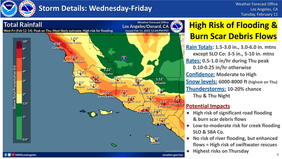
Updated storm timeline, anticipated totals
2:00 p.m.:

Evacuation Warning issued for OC canyons near Airport Fire burn scar
Orange County officials issued a voluntary evacuation warning for areas impacted by the Airport Fire. This includes:
- Trabuco Canyon
- Hot Springs
- Canyon
- Bell Canyon
- Long Canyon
- Modjeska Canyon
Officials warn of possible debris flow. The order goes into effect on Thursday, Feb. 13 at 8 a.m.
High Wind Warning
12:00 p.m.: A High Wind Warning is in effect from 1 p.m. Thursday to 1 a.m. Friday, the NWS said.
Southwest winds 25 to 35 mph with gusts up to 60 mph are expected for the Eastern San Gabriel Mountains, I-5 corridor, northern and southern Ventura County Mountains, Western San Gabriel Mountains, and Highway 14 corridor.
Free sandbags for residents
9:30 a.m.: FOX 11's Mario Ramirez is live in Pasadena where residents have been picking up sandbags to protect their homes.
Residents in Eaton Fire zone brace for storm
A flood watch has been issued by the NWS for parts of Los Angeles and Orange counties until Thursday night.
Mud and debris flow hotline
8:30 a.m.: LA County Dept. of Public Works Director Mark Pestrella announced the creation of a hotline that residents can call during any storm event to report mud and debris flow.
"Not only do we deal with flood control, we deal with sewer, water, storm drains, and streets," he said.
You can call 1-800-675-HELP to make a report.
Residents in ‘high impact areas’ being contacted
8:15 a.m.: Sheriff Robert Luna said formal evacuation warnings will likely be issued sometime Wednesday morning, possibly followed by evacuation orders depending how the storm develops Thursday.
"Please, if evacuation orders are made, ... keep your safety in mind," Luna said. "They help to protect you and your loved ones from potential danger. Storms can bring sudden and severe conditions that make staying back home extremely risky. ... Please take necessary steps now to prepare. Pack an emergency kit, secure important documents and ensure that you have a plan in place for your pets and family members.
"And remember, if you're ordered to leave, you may be gone for several days. I cannot stand up here and tell you will be gone for 12 hours, 24 hours. We don't know. It depends on the weather and the post-weather events that will impact your specific neighborhood."
Luna said deputies have also been canvassing flood-prone areas such as the Los Angeles River to warn homeless people who may be camped there to relocate.
‘Please don’t let your guard down'
8:00 a.m.: Sup. Kathryn Barger is urging residents - especially those in the Palisades and Eaton burn areas - to take all precautions as another atmospheric river predicted to be the biggest storm of the season is hitting the region.
"If you are advised to evacuate, please don't leave it to chance as a flash flood watch is in effect from Thursday afternoon to Friday morning," she said.
"Please heed the warnings to evacuate. Do not risk your life. We have learned important lessons from previous fires… where we saw the devastation the mud had on homes in the La Canada area. The foothill communities will be at an increased risk from the atmospheric rivers - so please don't let your guard down."
Anticipated rain totals, potential impacts
7:30 a.m.:
Residents in Eaton, Palisades fire zones
6:30 a.m.: Residents whose homes were spared in the Eaton and Palisades fire zones prepared for the incoming storm.
Heavy rainstorm to hit SoCal: TEAM COVERAGE
Residents and first responders were preparing for a severe storm expected to hit Southern California.
Storm system begins moving in
5:30 a.m.: Residents across Southern California can expect pockets of rain today, with the bulk of the storm expected Thursday into early Friday.
Southern California rain forecast
The bulk of the incoming storm is expected Thursday into early Friday.
SoCal braces for a severe storm
4:50 a.m.: The direct bullseye of the storm is expected to drench Southern California on Thursday. This storm is also expected to bring higher elevation mountain snow and windy conditions in the desert.
Weather Forecast for Wednesday, Feb. 12
The latest forecast for the greater Los Angeles area, including beaches, valleys and desert regions.
Be prepared to take action
Impacts and Precautions: Residents in areas prone to flooding should monitor forecasts and be prepared to take action if flooding develops. Those traveling in affected areas should exercise caution, as hazardous conditions could make travel difficult or impossible. It is advised to keep an extra flashlight, food, and water in vehicles in case of emergencies.
What’s Next: Residents should stay informed by checking the latest weather updates and road conditions. The National Weather Service advises calling 511 for state-specific road conditions.