

SoCal forecast: Residents in burn scar areas brace for another round of rain, possible t-storms

Weather forecast for Wednesday, March 5
The latest forecast and air quality conditions for the greater Los Angeles area, including beaches, valleys and desert regions.
LOS ANGELES - Light rain fell in parts of Southern California Wednesday, beginning two days of anticipated precipitation which is expected to douse the region.
The winter storm is expected to bring another round of gusty winds, widespread rain and mountain snow, as residents in some of Los Angeles County’s recent burn scar zones prepared to evacuate.
Rain began falling in some coastal areas during the morning rush hour, with the system then spreading slowly inland.
Overall rain totals are expected to be relatively low, according to the National Weather Service.

Rain in Los Angeles: Debris flow concerns in burn areas
A two-day rain storm is moving through Los Angeles and Southern California. Residents in the Palisades Fire and Eaton Fire burn scar areas face concerns of mudslides and debris flows.
"Much of Southern California will be seeing that rain in your evening commute, so keep that in mind to take it nice and easy out there if you’re hitting the roadways," said FOX 11 Meteorologist Soumada Khan.
The storm comes as most parts of Southern California are in a drought.
"Even though we got all that rain in February, it still doesn’t compare to all the rain we didn’t get," FOX 11 Meteorologist Maria Quiban said.
LA County’s recent burn scar zones brace for evacuations
What we know:
The latest in a series of storms is expected to pack a punch. Most areas across Southern California are forecast to receive somewhere between half an inch to an inch of rain.
Ahead of the storm, an evacuation warning was issued in Sierra Madre.

Rain brings mud onto PCH in Malibu
More rain in Los Angeles caused some mud to spill onto PCH on Wednesday.
"This is what concerns me because if we do get those thunderstorms, that can cause mud and debris flow. That’s why part of the Eaton Fire zone has that evacuation warning preparing you for that potential [situation]," said Quiban.

Sierra Madre residents prepare to evacuate
Ahead of a storm expected to slam Los Angeles County, an evacuation warning was issued in Sierra Madre.
This storm is expected to last through Friday.
How much rain is expected in Southern California?
By the numbers:
The amount of rain forecast to hit the region varies.
"Half an inch to over an inch of rain is possible for just about anywhere. Foothills and mountains, a range of 1 to 3 inches, and even our desert communities are looking at about a quarter of an inch or less."
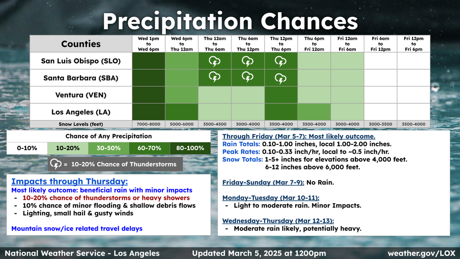
Also, it isn’t just rain, there’s also snowfall.
"There’s a lot of snow on the way. A Winter Weather Advisory will be in place for the Ventura County and LA County mountains, and this does apply to the Grapevine as well," Khan said.
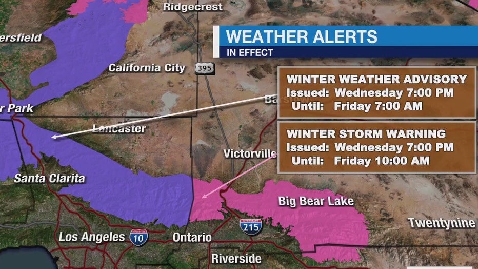
A Winter Storm Warning goes into effect for the San Bernardino County Mountains from 7 p.m. Wednesday to 10 a.m. Friday. The latest storm is expected to bring heavy snow to the area. The National Weather Service expects the following snowfall amounts:
- Between 4 and 8 inches for elevations of 5000 to 6000 feet
- Between 8 and 12 inches for elevations of 6000 to 7500 feet
- Between 12 and 16 inches for elevations above 7500 feet
- Over a foot of snow for elevations of 8000 feet and above
Snow levels are expected to drop to 4,000 feet Wednesday night and could impact travel for the mountain passes, including The Grapevine.
She continued to explain, "Snow levels will continue to drop late Thursday into early Friday and that will lead to some severe weather conditions. A Winter Storm Warning will apply to the San Bernardino and Riverside County mountains due to wind gusts that could reach up to 40 to even 50-plus miles per hour."
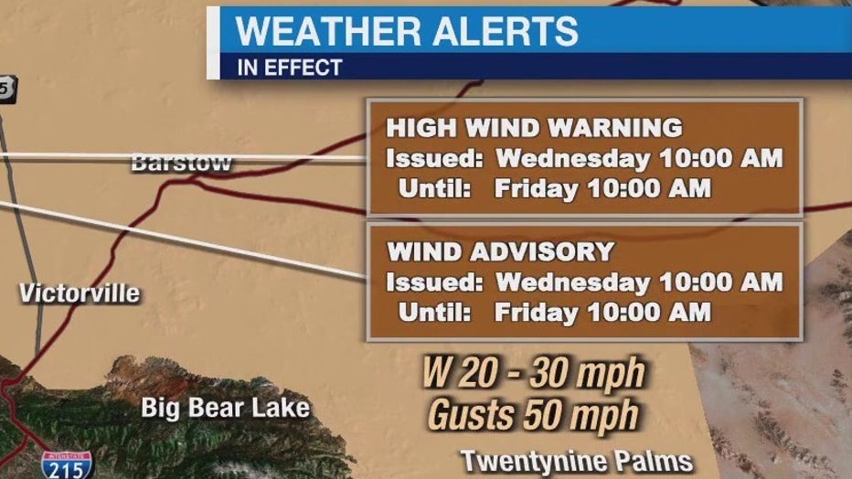
Wind alerts will also go into effect Wednesday morning through Friday morning.
"If you’re having travel plans through the 15 [Freeway], through our desert communities, you want to be extra cautious," said Khan.
What's next:

Weather Forecast for Wednesday, March 5
The latest forecast and air quality conditions for the greater Los Angeles area, including beaches, valleys and desert regions.
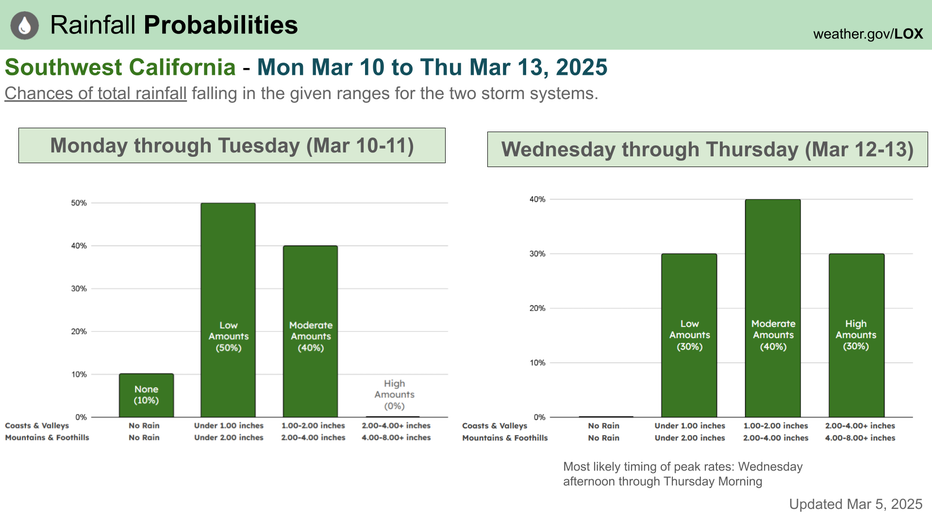
It will be dry through the weekend before another storm moves into the area early next week.
The Source: Information from FOX 11's Weather Team and the National Weather Service.