

Southern California forecast: Timeline of what to expect in the coming days
Safety tips for the storm
"Your personal safety is your priority," said LAFD Chief Kristin Crowley. She added that drowning was the leading cause of flood deaths.
LOS ANGELES - Residents across Southern California are bracing for a powerful second storm system after the first hit the region, bringing heavy rain that led to some flooding, gusty winds, high surf, and mountain snow. Meteorologists caution the second storm is forecast to be even stronger.
"Storm number two is going to bring us some significant impacts. So, I want you to be prepared for the series of days here of more rain and snow and, of course, flooding and all the stuff that comes with all of this water," said FOX 11 Meteorologist Maria Quiban during Good Day LA on Friday.
Preparing for the big storm this weekend
Emergency management officials across Southern California are taking an all-hand-on-deck approach to storm preps as heavy rain and flooding are among the major concerns this coming weekend.
"This storm could end up generating unprecedented amounts of rain across a widespread area! Once again, this is potentially a very dangerous situation and everyone in this area needs to take precautions now," the National Weather Service said.
Below is a timeline of what to expect this weekend and into next week, as a second atmospheric river approaches the region.

A view of downtown Los Angeles on the morning of Friday, Feb. 2, 2024. (KTTV SkyFOX)
Friday, Feb. 2
Friday brought some isolated showers in the morning for parts of the Southland, while there was a chance of snow showers in the San Bernardino County mountains. The first storm tapered off Friday afternoon, making way for mostly sunny skies and partly cloudy skies on Friday night.
Weather Forecast for Friday, Feb. 2
The latest forecast and air quality conditions for the greater Los Angeles area, including beaches, valleys and desert regions.
An evacuation warning has been issued for parts of Santa Barbara County in the wake of the storm that is expected to hit the area Saturday. As of 4 p.m. Friday, the evacuation warning has not been upgraded to an evacuation order.
Saturday, Feb. 3
Saturday also brings mostly sunny skies with cooler temperatures hovering around the 60-degree mark. A 50% chance of rain begins at 10 p.m. for most of Southern California. Those in the mountain communities can expect increasing clouds and a slight chance of snow after 4 p.m.
The National Weather Service (NWS) warns of hazardous conditions along the coast from Saturday night through Wednesday.
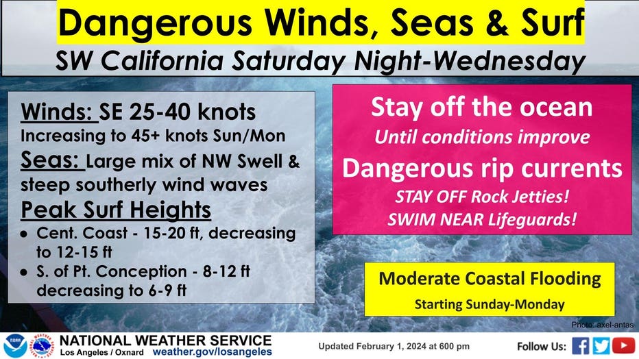
(National Weather Service)
"Don't be surprised if we get pockets of moisture late [Saturday]. We'll start to see those showers. And then heavy rain on Sunday. Monday, and Tuesday, "said Quiban.
Sunday, Feb. 4 and Monday, Feb. 5
Forecast models show the peak of the storm will strike Sunday and Monday, starting in Santa Barbara and Ventura counties before moving southward. "We are going to perhaps double the amount of rain we would typically get in one month in just several days," Quiban added.
As the atmospheric river targets the region, the NWS warns of strong winds that will move in by Sunday. The NWS predicts they could issue wind advisories throughout the region.
Also, intense rainfall by the end of the weekend into early next week brings the risk of life-threatening and damaging flooding. Parts of Southern California could see between 3 and 6 inches of rain, and between 6 and 12 inches in the mountains and foothills. The NWS anticipates they will issue flood advisories during that time.
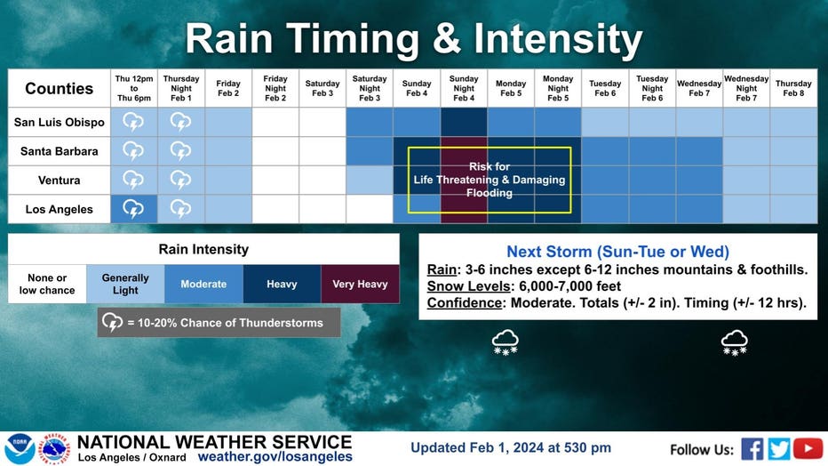
(National Weather Service)
Snow levels are estimated to drop between 6,000 and 7,000 feet.
Tuesday, Feb. 6 through Thursday, Feb. 8
Lingering rain chances continue Tuesday, Wednesday and Thursday. The NWS added snow levels could drop to elevations as low as 3,500 feet, which may impact travel along the Grapevine.
Staying safe from the storm
During a press conference Friday evening, Mayor Karen Bass and Los Angeles Fire Department Chief Kristin Crowley gave the public tips on how to stay safe.
- Never drive through flooded areas where the pavement is not visible.
- If you are stranded in your car, move to the hood or roof if the water rises.
- Stay away from power lines and report downed lines to the DWP.
"Your personal safety is your priority," Crowley said.
Free, ready to fill sandbags are available to pick up at local fire stations. Visit LAFD.org for select locations. You can report any storm related damages by calling 311.