California rain: Timeline, evacuations as atmospheric river moves into SoCal
Atmospheric river comes to SoCal
Southern California is bracing for an atmospheric river storm that's threatening big waves, severe flooding and more.
LOS ANGELES - Ahead of the strong storm expected to hit Los Angeles Sunday, Mayor Karen Bass encouraged Southern California residents to stay vigilant and prepare.
"The city has been working urgently in anticipation of the storm that's expected to hit us Sunday, Monday and possibly Tuesday," Bass said during a Friday afternoon news conference.
"We know that weather predictions can change quickly, but right now there are indications that the coming storm could be as strong as Tropical Storm Hilary was in August."
She reassured city residents that the city will once again be prepared for what may come. Bass emphasized taking common-sense precautions, such as staying home and staying off the road starting Sunday.
Here's what Angelenos can expect from the rain in California this week:
Timeline
SUNDAY, FEB. 4
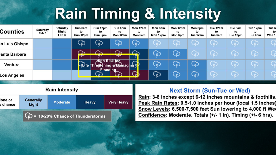
The powerful atmospheric river is expected to arrive Sunday, forecasters said. A wind advisory in LA County begins at 6 a.m. and the flood watch begins at 12 p.m., according to the NWS, and goes through 4 p.m. Tuesday.

Very heavy rain is expected to hit Los Angeles County by 6 p.m., Sunday and continue throughout the rest of the night. Thunderstorms are expected, and potentially life-threatening flash flooding during this time is a top concern for officials.
Further north, heavy rain is expected earlier in the day. Flood watches have been issued for Santa Barbara, Ventura and San Luis Obispo counties for 1 a.m. Sunday, through 4 p.m. Tuesday.
SUGGESTED: Cars submerged in water in Long Beach as atmospheric river brings major flooding
This multiple-day storm could drop three to six inches of rain in coastal and valley areas, and six to 12 inches in the mountains, with much of that downpour occurring in a 24- to 36-hour period between Sunday into Monday, the NWS said.
The Getty Center and Villa announced it would be closed Sunday and Monday.
The Surf City Marathon Half Marathon and 5K races will go on in Huntington Beach, rain or shine, according to organizers, who promised to notify participants through email and social media if there are changes in plans.
MONDAY, FEB. 5
Heavy storm conditions are expected to continue into Monday in LA County.
"People need to start preparing now for a major flooding event," National Weather Service forecasters warned.
The heavy rain will be accompanied by strong winds in many areas, blowing at speeds of 30 to 50 mph in parts of L.A. County, and reaching up to 60 to 90 mph in higher mountain areas and the 5 Freeway corridor, forecasters have predicted.
PREVIOUS COVERAGE: Rain in LA: 1st of 2 atmospheric rivers arrives in Southern California
"The Los Angeles River will fill quickly and become a raging river and a very dangerous place to be," said the NWS. "Anyone in that basin should be removed well before the onset of rain. Creeks and streams may rise out of their banks. Flooding may occur in poor draining and urban areas. Low-water crossings may be flooded. Storm drains and ditches may become clogged with debris. Extensive street flooding and flooding of creeks and rivers are possible."
TUESDAY, FEB. 6 AND BEYOND
The wet weather pattern will continue into Tuesday evening, with periods of rain anticipated to continue.
SUGGESTED: California's 'ARkStorm': Historic 1000-year floods of 1861-62 featured 8 weeks of atmospheric rivers
Drier conditions are expected by Wednesday, but a chance of showers will still linger. Snow levels could fall as low as 3,500 feet by Thursday, forecasters said.

"Now to the residents of our great city, we urge you to take this storm seriously and prepare accordingly," said LA City Fire Chief Kristin Crowley. "Please ensure that your emergency kits are updated, avoid any unnecessary travel, and stay informed through official channels for updates."
Los Angeles County
Evacuation Orders
- La Tuna Canyon Road area north of Hollywood Burbank Airport (afected area borders Horse Haven Street to the north, Martindale Avenue to the east, Penrose Street to the south, and Ledge Avenue to the west.
- Owen Fire area on Santa Maria Road from Topanga Canyon (now through 6 p.m. Tuesday)
- Agua Fire area along Soledad Canyon Road east of Agua Dulce Canyon Road (now through 6 p.m. Tuesday)
- Fish Fire burn scar area in Duarte on Mel Canyon Road between Fish Canyon Road and Brookridge Road in effect from 6 p.m. Sunday through 10 a.m. Tuesday.
Evacuation Warnings
- Unincorporated Los Angeles County near burn scars from 10 a.m. Sunday through 6 p.m. Tuesday, including the Juniper Hills and Valyermo areas from the Bobcat Fire
- Lake Hughes and King Canyon from the Lake Fire (20000 block of Pine Canyon Road; 18000 block of Ellstree Drive; 46000 block of Kings Canyon Road; 18000 block of Newvale Drive; 43000 block of Lake Hughes Road
Evacuation Shelters
- Sunland Senior Citizen Center at 8640 Fenwick St. (people and household pets)
- Lake View Terrace Recreation Center at 11075 Foothill Blvd. (people and household pets)
- Large animals can be evacuated to Hansen Dam Horse Park at 11127 Orcas Ave. in Lake View Terrace, and the LA Equestrian Center at 480 Riverside Drive in Burbank
See a map of all evacuation orders in LA County by tapping or clicking here.
Ventura County
Evacuation Orders
- Matilija Canyon / North Fork / Camino Cielo (Unincorporated Ojai)
Evacuation Warnings
- Ventura RV Resort (City of Ventura)
- Community of Foster Park / Camp Chaffee (Unincorporated Ventura)
- Old Creek Road. / Creek Road (Unincorporated Ojai)
- 4 structures on Grada Avenue & Trueno Avenue (Unincorporated Camarillo)
Evacuation Advisory
- Community of La Conchita
Evacuation Shelters
- Ventura College Gymnasium (4667 Telegraph Road, Ventura, CA 93003)
A full map of evacuation orders and more in Ventura County can be found by tapping or clicking here.

