Next tropical threat brewing in Caribbean with eyes on Gulf as development odds increase
Area of low pressure in Caribbean could form
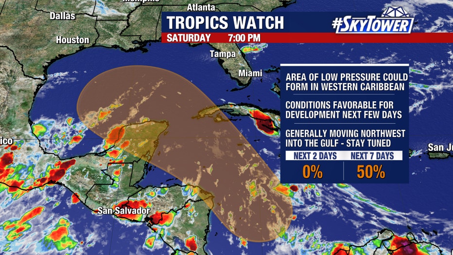
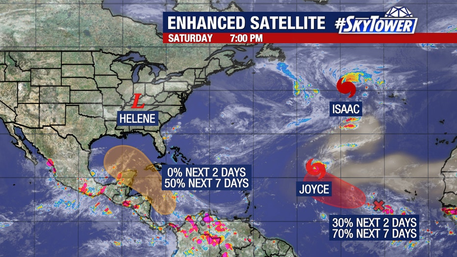
FOX 13 News Meteorologist Valerie Mills says an area of low pressure in the western Caribbean could form and is moving northwest into the Gulf of Mexico. Mills says a wave in the Atlantic, Tropical Storm Joyce and Hurricane Isaac are also being monitored.
MIAMI, Fla. - The Southeast is still reeling from Hurricane Helene's deadly punch, but attention will soon need to return to the Caribbean as the tropics’ next act begins to brew, with steadily increasing odds of another tropical system developing within the next week.
Forecast models indicate a new area of low pressure is expected to form over the western Caribbean Sea by early next week, according to the National Hurricane Center (NHC).
The low could then find environmental conditions favorable for development as it moves into the western Gulf of Mexico around the middle of next week, where it could form into a tropical depression, the NHC said.

The Cental America Gyre – which had a big hand in the birth of Hurricane Helene – is set to redevelop, but with a few important differences.
"The CAG is nowhere near as strong in the computer forecasts this time as it was before Helene formed," FOX Weather Hurricane Specialist Bryan Norcross said. "And the upper air pattern is quite different."
It’s too early to tell where or how strong the system will become in the days after, but so far the NHC is giving medium odds of developing into at least a tropical depression within the next seven days. Those odds, however, have jumped from 30% to 50% just in the last day.

"The atmospheric pattern looks reasonably conducive for a tropical system to try to form and then track from the western Caribbean toward the Gulf of Mexico late in the week," Norcross said. "The same caveats we discussed last week are still important. All forecasts for undeveloped or just developing systems are subject to change and large errors. Don't focus on any specific forecasts at this point."
Another area to watch in the Atlantic
Similar to the budding Caribbean storm, another area of low pressure is finding conditions conducive for gradual development. Only this one is far out in the Atlantic Ocean.
The NHC said this storm could form in the wake of Tropical Storm Joyce, and a new tropical depression could form next week, giving high odds of development in the next seven days.

Those two areas of burgeoning tropical development join two storms that have already reached at least tropical storm status in the Atlantic and have been given the 9th and 10th names on the 2024 tropical cyclone name list.
Isaac has even developed into a Category 2 hurricane as it swirls across the northern Atlantic. Tropical Storm Joyce sits about 800 miles northeast of the Leeward Islands but is turning to the north and expected to gradually weaken.
Neither storm is a threat to land.
Source: FOX Weather

